Sticky
FROST ADVISORY IN EFFECT FROM MIDNIGHT TONIGHT TO 9 AM EDT FRIDAY…
2024-04-25
* WHAT… Temperatures as low as 33 degrees will result in frost formation.
* WHERE… Portions of north central, northeast, and northwest Ohio.
* WHEN… From midnight tonight to 9 AM EDT Friday.
* IMPACTS… Frost could harm sensitive outdoor vegetation. Sensitive outdoor plants may be killed if left uncovered.


Sticky
Overnight and Tomorrows forecast 4/ 25-26
2024-04-25
Tonight – Widespread frost. Low 32°F. Wind ENE, 3 to 8 mph.
Tomorrow 4-26 – Overcast, High 68°F. Wind ESE, 5 to 15 mph.
Tomorrow night – 60% showers & T-storm, Low 58°F. Wind SSE, 5 to 15 mph.
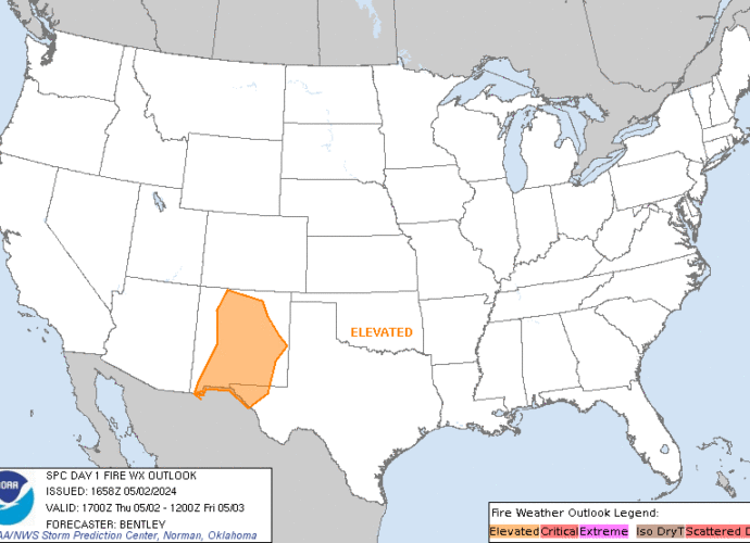
SPC Day 1 Fire Weather Outlook
2024-04-25
SPC Day 1 Fire Weather Outlook
Day 1 Fire Weather Outlook
NWS Storm Prediction Center Norman OK
1120 AM CDT Thu Apr 25 2024

Valid 251700Z - 261200Z

...CRITICAL FIRE WEATHER AREA FOR THE SOUTHERN HIGH PLAINS AND
SOUTHERN NEW MEXICO...

Elevated to critical conditions have started to develop across
southeast New Mexico. Expect these conditions to expand/worsen
through the day as mid-level flow strengthens and lee cyclogenesis
continues. Expanded the Elevated delineation slightly farther north
based on current and expected position of the front and dryline.
Otherwise, no changes were necessary. See previous discussion below.

..Bentley.. 04/25/2024

.PREV DISCUSSION... /ISSUED 0114 AM CDT Thu Apr 25 2024/

...Synopsis...
A midlevel trough will track eastward across the Southwest, while an
accompanying 60-70-kt midlevel southwesterly jet overspreads
southern NM and the southern High Plains. This will promote rapid
deepening of a lee cyclone over eastern CO, while a
southward-extending dryline sharpens over west TX. This large-scale
pattern evolution will yield an expansive area of critical
fire-weather conditions across the aforementioned areas, with
high-end critical conditions expected over eastern NM.

...Southern New Mexico and the Southern High Plains...
Behind the sharpening dryline, strong downslope warming/drying and
diurnal heating will contribute to a deep/dry boundary layer,
characterized by surface temperatures in the mid/upper 80s and
single-digit to lower-teens RH. Here, a tightening surface pressure
gradient peripheral to the deepening lee cyclone, and mixing into
the strong flow aloft, will support 25-35 mph sustained
southwesterly surface winds (with gusts upwards of 45 mph). These
conditions will yield an expansive area of high-end critical
fire-weather conditions, given modestly receptive fuels.

The overlap of strongest winds and lowest relative humidity is
expected over eastern NM, where extremely critical meteorological
conditions are likely. However, a lack of abundant and very dry
fuels over the area precludes such highlights at this time.

...Please see www.spc.noaa.gov/fire for graphic product...

SPC Day 2 Fire Weather Outlook
2024-04-25
SPC Day 2 Fire Weather Outlook
Day 2 Fire Weather Outlook
NWS Storm Prediction Center Norman OK
0220 PM CDT Thu Apr 25 2024

Valid 261200Z - 271200Z

...CRITICAL FIRE WEATHER AREA FOR THE SOUTHERN HIGH PLAINS AND
SOUTHERN NEW MEXICO...

No changes. See previous discussion below.

..Bentley.. 04/25/2024

.PREV DISCUSSION... /ISSUED 0114 AM CDT Thu Apr 25 2024/

...Synopsis...
A midlevel low and attendant surface cyclone will advance
northeastward from the central Plains into the Upper MS Valley. On
the backside of this system, a belt of strong deep-layer
west-southwesterly flow will persist across a post-dryline
environment over southern NM and parts of the southern High Plains.
This will favor another day of critical fire-weather conditions
across the region during the afternoon.

...Southern New Mexico and much of the Southern High Plains...
Along the southwestern periphery of the primary surface cyclone, a
tight pressure gradient will persist across the area. This, combined
with boundary-layer mixing into the strong flow aloft, will yield
20-25 mph sustained west-southwesterly surface winds (with higher
gusts). At the same time, continued downslope flow amid a dry
antecedent air mass will contribute to 10-15 percent afternoon RH.
As a result, critical fire-weather conditions are expected across
southern NM and much of the southern High Plains, given increasingly
dry fuels over the area.

...Please see www.spc.noaa.gov/fire for graphic product...

SPC MD 513
2024-04-25
SPC Mesoscale Discussions
MD 0513 CONCERNING SEVERE POTENTIAL…WATCH LIKELY FOR NORTHEAST COLORADO INTO MUCH OF NORTHWEST KANSAS
Mesoscale Discussion 0513
NWS Storm Prediction Center Norman OK
0223 PM CDT Thu Apr 25 2024

Areas affected...northeast Colorado into much of northwest Kansas

Concerning...Severe potential...Watch likely

Valid 251923Z - 252200Z

Probability of Watch Issuance...95 percent

SUMMARY...Storms are expected to rapidly develop along the boundary
from northeast Colorado into northwest Kansas, and far southwest
Nebraska. Very large hail is likely, along with a few tornadoes and
damaging gusts.

DISCUSSION...Strong heating persists across the region, now on both
sides of a stationary front extending from northeast CO into
northwest KS. Southeasterly surface winds have brought 50s F
dewpoints westward into CO, which is contributing to up to 2000 J/kg
MUCAPE within the narrow moist plume. Moderate southwest flow aloft
atop the backed low-level southeasterlies is further aiding shear
near the boundary which strongly favors long-lived severe storms.
Supercells or bows will be possible producing very large hail, a few
tornadoes and damaging gusts.

..Jewell/Hart.. 04/25/2024

...Please see www.spc.noaa.gov for graphic product...

ATTN...WFO...LBF...DDC...GLD...BOU...

LAT...LON   38840054 38690063 38620074 38550110 38870201 39380281
            39530324 39720340 39990338 40240327 40400311 40480274
            40470196 40420132 40240087 39970060 39580042 39020048
            38840054
https://www.spc.noaa.gov/products/md/md0513.htmlSPC Mesoscale Discussions

SPC Apr 25, 2024 1630 UTC Day 1 Convective Outlook
2024-04-25
SPC 1630Z Day 1 Outlook
Day 1 Convective Outlook
NWS Storm Prediction Center Norman OK
1124 AM CDT Thu Apr 25 2024

Valid 251630Z - 261200Z

...THERE IS AN ENHANCED RISK OF SEVERE THUNDERSTORMS THIS EVENING
ACROSS WESTERN KS AND TONIGHT ACROSS NORTHWEST TX INTO CENTRAL OK...

...SUMMARY...
Very large hail up to 3 inches in diameter and a strong tornado or
two will be possible this evening across western Kansas.  Large
hail, damaging winds to 70 mph and a few tornadoes will be possible
tonight from northwest Texas into central Oklahoma.

...Synopsis...
Morning water vapor imagery shows a negatively-tilted shortwave
trough rotating across UT/AZ, with an associated 70kt mid-level jet
max moving into NM.  This system will eject into the
central/southern Plains this evening/tonight, resulting in multiple
clusters of severe thunderstorm activity.

...Western KS...
A quasi-stationary surface boundary extends from northwest CO into
northwest KS.  Visible imagery shows broken cloud cover across
western KS this morning, with dewpoints in the low 60s to the south
of the front.  Strong heating will likely ensue through the
afternoon, resulting in deepening mixing to the east of the dryline
and eventual isolated thunderstorm development.  CAM solutions
differ significantly on coverage of convection, but it appears
likely that at least isolated supercells will form along the
dryline, capable of very large hail, damaging winds, and a few
tornadoes (possibly strong).

The confidence of initiation is much higher along the warm front
from northeast CO into northwest KS, and forecast soundings along
this corridor show strong low-level vertical shear supporting
supercell structures.  It is uncertain how far north these storms
can remain surface-based, but there is an apparent tornado risk
(possibly strong) along the immediate boundary and a large hail risk
for some distance northward.  This activity will likely spread into
south-central NE after dark.

...TX Panhandle/Western OK...
As the primary upper trough ejects this evening, large-scale height
falls and forcing will overspread the dryline across the OK/TX
Panhandles.  Forecast soundings show a persistent capping inversion
along the dryline, and CAM guidance generally shows very isolated
convective initiation.  Any storm that forms will pose a risk of all
severe hazards, including very large hail.

Overnight, a strengthening low-level jet over west TX will likely
lead to a large cluster of thunderstorm.  These storms will track
northeastward across northwest TX and into western/central OK in the
pre-dawn hours.  Large hail will be likely with these storms, but
damaging winds and isolated tornadoes will also be a risk if a more
organized linear MCS can evolve.

..Hart/Moore.. 04/25/2024
SPC Apr 25, 2024 1730 UTC Day 2 Convective Outlook
2024-04-25
SPC 1730Z Day 2 Outlook
Day 2 Convective Outlook
NWS Storm Prediction Center Norman OK
1230 PM CDT Thu Apr 25 2024

Valid 261200Z - 271200Z

...THERE IS AN ENHANCED RISK OF SEVERE THUNDERSTORMS ACROSS PARTS OF
EASTERN NEBRASKA/NORTHEAST KANSAS INTO NORTHWEST MISSOURI AND
WESTERN/CENTRAL IOWA...

...SUMMARY...
Severe thunderstorms appear likely on Friday from parts of eastern
Nebraska/northeast Kansas into northwest Missouri and Iowa, and
continuing southward into parts of the southern Plains and Ozarks.
Tornadoes (some strong), large to very large hail, and damaging
winds will all be possible.

...Synopsis...
A negatively tilted upper trough over the central Plains Friday
morning will continue to eject northeastward across the Upper
Midwest through the period. A 50-70 kt mid-level jet will accompany
this upper trough, and aid in strong deep-layer shear needed for
thunderstorm organization. A broad southerly low-level jet will be
in place from parts of the southern Plains/Ozarks northward to IA.
Low-level moisture will stream northward from the central Plains
into the parts of the Upper Midwest in response, ahead of a deep
surface low developing northeastward across NE/SD through Friday
evening.

...Eastern Nebraska/Northeast Kansas into Northwest Missouri and
Iowa...
Showers and thunderstorms will likely be ongoing at the start of the
period Friday morning across this region, associated with persistent
lift and the southerly low-level jet. Most of this activity should
tend to remain sub-severe, but isolated hail and gusty winds could
occur. In the wake of this morning convection, a narrow zone of
moderate instability will likely develop across parts of eastern
NE/KS ahead of a surface cold front/dryline. Better forcing
aloft/mid-level height falls associated with the upper trough should
remain on the northern extent of the low-level moisture return and
developing warm sector.

Still, most high-resolution guidance shows robust convective
development by mid Friday afternoon across the eastern NE/northeast
KS vicinity. Strong low-level and deep-layer shear will favor
supercells with attendant threat for tornadoes and very large hail
as these thunderstorms spread into northwest MO and western/central
IA through Friday evening. Given the degree of low-level shear
associated with the 45-55 kt southerly low-level jet, some of these
tornadoes could be strong. The surface warm front draped across
northern/central IA will serve as the northern limit for an
appreciable tornado threat, although some supercells could continue
to pose a threat for large hail even if they become slightly
elevated to the north of the warm front. Based on latest guidance
trends, the Enhanced Risk for tornadoes and large hail has been
adjusted a little northward across eastern NE into IA.

...Southern Plains into the Mid Mississippi Valley/Mid-South...
Initially strong to locally severe thunderstorm clusters are
expected to move across eastern OK/KS and potentially northeast TX
into AR and MO through Friday morning. This activity should pose at
least an isolated severe hail and damaging wind threat before it
eventually weakens. Some of this convection may persist or tend to
regenerate along the eastern periphery of the primary instability
axis, especially across parts of southern MO into AR. The eastern
extent of any severe threat remains uncertain, but favorable
low-level and deep-layer shear could support occasionally organized
convection into the mid MS Valley/Mid-South, with an isolated threat
for large hail, damaging winds, and perhaps a few tornadoes
persisting.

Farther west, moderate to strong instability and strong deep-layer
shear will support a conditionally favorable environment along the
dryline from eastern OK into northeast TX. In the wake of the
departing upper trough to the north, additional development along
the dryline across this region should remain very
isolated/conditional. Even so, any sustained cells would pose a
threat for very large hail and a tornado.

...Northwest Texas...
The dryline will retreat westward across parts of west/northwest TX
late Friday night. Isolated to scattered thunderstorms may form
prior to the end of the period into parts of northwest TX, in
advance of another approaching upper trough over the Southwest.
MUCAPE and deep-layer shear appear sufficient for organized
convection, and isolated large hail may occur with any elevated
thunderstorms that can develop early Saturday morning.

..Gleason.. 04/25/2024

SPC MD 512
2024-04-25
SPC Mesoscale Discussions
MD 0512 CONCERNING SEVERE POTENTIAL…WATCH POSSIBLE FOR SOUTHEAST WYOMING INTO SOUTH DAKOTA AND NORTHWEST NEBRASKA
Mesoscale Discussion 0512
NWS Storm Prediction Center Norman OK
0151 PM CDT Thu Apr 25 2024

Areas affected...Southeast Wyoming into South Dakota and northwest
Nebraska

Concerning...Severe potential...Watch possible

Valid 251851Z - 252045Z

Probability of Watch Issuance...60 percent

SUMMARY...Thunderstorms are expected to gradually intensify through
the afternoon hours across parts of southeast Wyoming, western South
Dakota, and northwest Nebraska. This activity will primarily pose a
severe hail risk, though a few severe gusts are also possible.

DISCUSSION...Over the past 1-2 hours, high-based convection
developing off the higher terrain of central WY, along with
additional convection along a deepening surface trough, has migrated
into a narrow plume of returning moisture noted in surface
observations (dewpoints in the low to mid 50s). Steep lapse rates
between 8-9 C/km noted in 12 UTC soundings remain entrenched over
the region with upper-level ascent increasing with the approach of
synoptic wave from the southwest. This combination of improving
moisture and steep lapse rates is supporting MLCAPE values upwards
of 1000 J/kg over a region with increasing ascent. Consequently,
thunderstorm coverage and intensity is forecast to increase through
the afternoon. While stronger mid-level flow is displaced to the
south, elongated hodographs featuring 30 knot winds near the 6 km
level should support organization of semi-discrete cells and
thunderstorm clusters with an attendant threat for large hail (most
likely between 0.75 to 1.5 inches in diameter). Additionally, 20-30
F dewpoint depressions indicate steep low-level lapse rates that
should support the potential for a few severe gusts - especially if
a more organized cluster with a consolidated cold pool can become
established.

..Moore/Hart.. 04/25/2024

...Please see www.spc.noaa.gov for graphic product...

ATTN...WFO...LBF...UNR...CYS...

LAT...LON   41400497 42890500 43730424 45270256 45320203 44820147
            44430131 43640208 42700284 41700349 41140400 41100456
            41400497
https://www.spc.noaa.gov/products/md/md0512.htmlSPC Mesoscale Discussions